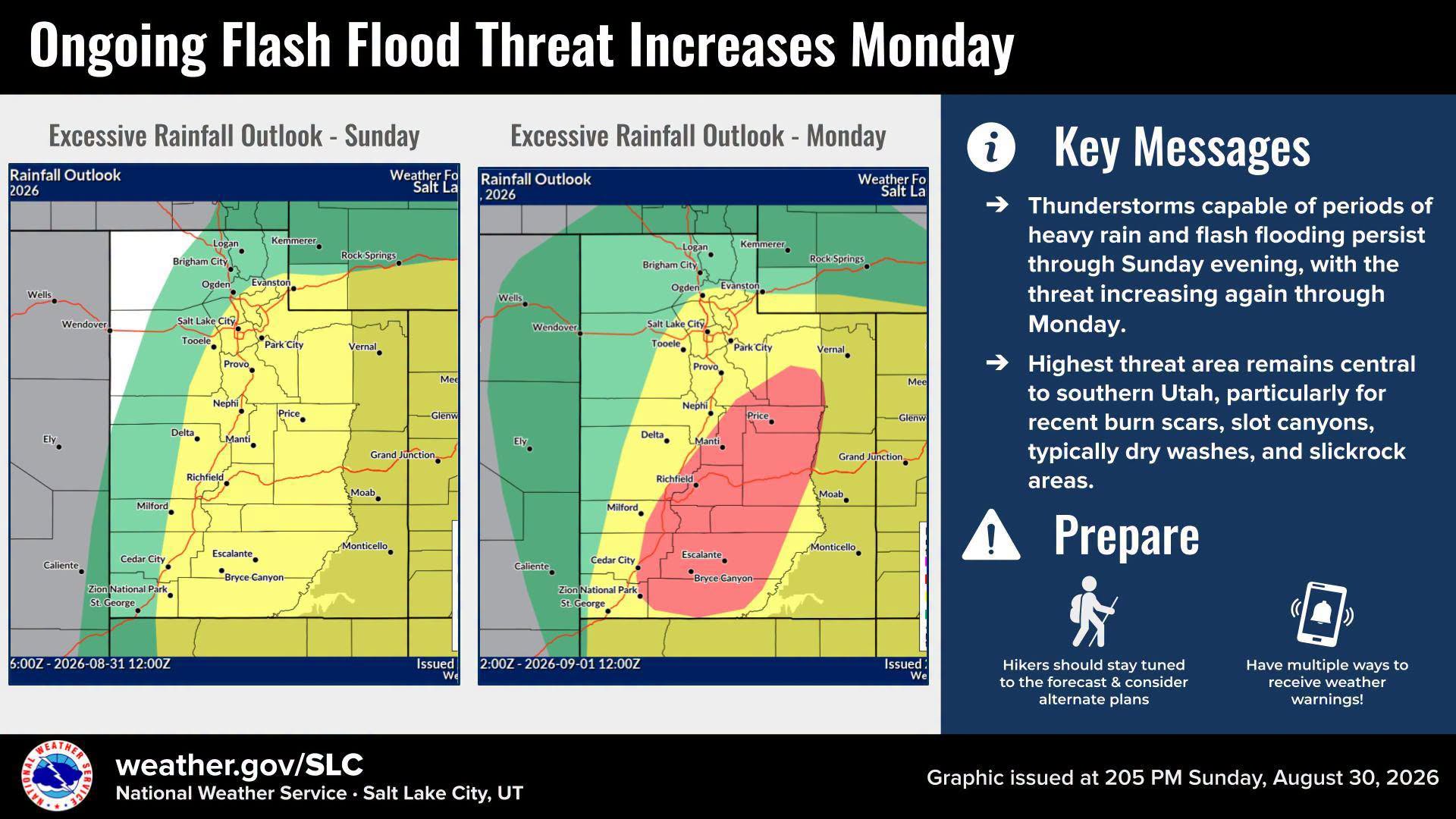
Heavy rain and thunderstorms are pushing flash-flood risk across the Wasatch Front through Monday evening, and Millcreek falls within the threat area.
The National Weather Service issued a Flood Watch for portions of central and southern Utah, in effect through Monday evening, Aug. 31. A 15% risk of excessive rainfall covers locations along and east of I-15, which includes most of the Wasatch Front, ABC4 meteorologist Noah Price reported Sunday, Aug. 30.
The NWS Salt Lake City office warned Monday that the threat would escalate through the day. The agency identified a Moderate Risk, rated 3 out of 4, of excessive rainfall for portions of southern to central Utah on Monday. The highest-threat areas are rain-sensitive basins: recent burn scars, slot canyons, dry washes and slickrock terrain.
The NWS Salt Lake City advised anyone planning recreation in those areas to consider alternative plans and urged everyone in the threat area to stay weather-aware.
Burn scars increase flood danger
Four burn scars are drawing the most concern. "The highest concern areas will remain in our recent burn scar areas such as the Cottonwood, Widemouth 2, Forsyth, and Monroe Canyon scars," Price wrote Sunday.
The Cottonwood Fire scar in Beaver and Piute counties burned 97,000 acres earlier in 2026. Just half an inch of rain over that scar on Aug. 10 triggered evacuations near Beaver Canyon after producing a debris flow. Utah wildfires had scorched more than 505,000 acres as of mid-August, according to a KSL report cited in Millcreek Times coverage Aug. 12.
What Millcreek residents should know
Millcreek Canyon's narrow terrain and dry washes make it vulnerable during heavy afternoon downpours, even when no watch or warning names the canyon specifically. The upper portion of Millcreek Canyon Road remains closed for a federally funded road improvement project expected to continue through fall 2026.
Severe to extreme drought conditions persist across much of Utah, according to the NWS Salt Lake City's August 2026 drought impact statement.
When conditions ease
ABC4 forecasts drier conditions Tuesday, Sept. 1, with only slight rain chances at higher elevations and temperatures trending near or slightly below average. Daytime highs are expected in the 70s for northern Utah.
The flood threat is expected to drop but not disappear. Flood-prone and rain-sensitive areas will remain at risk. Long-range models show another possible surge of moisture moving into Utah toward the end of next week, according to ABC4.
Residents can monitor conditions at weather.gov/slc and sign up for emergency alerts through Salt Lake County's notification system.